We’ve had an exciting few months at Eloy as the team along with White Willow Consulting, KL Systems, and the RAC Foundation prepared a connected car solution – a “pathfinder” – for the world’s oldest motoring event.
The London to Brighton Veteran car run took place on Sunday 7th November and is an annual event that marks the 1896 Light Locomotives on the Highway Act that raised the speed limit for light locomotives from 4 mph to 14 mph. The Act also abolished the requirement for cars to be preceded by a man on foot holding a red flag.
Eloy’s Apple iOS app and KL Systems’ Android app demonstrated how mobile technology can be used to inform drivers of even the oldest cars about road conditions, hazards, accidents, and traffic. We also demonstrated how sat nav based solutions can be used to improve in-car experiences.
Huge thanks to everyone involved, in particular Andy Graham, Steve Gooding, and George Brown. More can be found here.
What do you mean by the world's oldest connected cars?
For this pathfinder, 3 120-year-old cars were fitted with mobile phones installed with connected vehicle apps that provided in-vehicle digital services to the vehicle occupants and other stakeholders including the event organisers.
Connected vehicle solutions are wide ranging but are often seen as the forgotten part of the 3 key areas of road vehicle evolution; autonomous and electric vehicles being more widely understood.

A 1901 Mors fitted with the Eloy app ready to set off from Hyde Park
One of the reasons connected vehicles are often overlooked is that they can appear to have fewer tangible benefits. An electric car is obviously electric and has low roadside emissions. An autonomous car drives itself so you can watch Netflix on the way to work. But what does a connected car do?
It can actually do a great deal, and connectivity is the foundation of how both electric and autonomous vehicles will function. There are also widening use cases focused on improved in-vehicle decision making that go far beyond the original consultancy brainstorms.
In short, the pathfinder set out to showcase some of the solutions that are readily available today and will allow Eloy and the team to build a suite of software tools that could be used for other connected vehicle applications, including Smart Parking, Smart Motorway Sat Nav Modes, Scenic Driving Guides, and much more.
Each of these new product areas will need exploring, but together they will reduce congestion, make it easier to find parking spaces, improve road safety, and make trips more enjoyable in safe ways.
The tools at our disposal
Across both mobile apps used in the pathfinder, we had numerous technologies at our disposal. This included messages delivered via in-vehicle signage (IVS), speed display, sat navigation, vehicle tracking, as well as several ways to override standard app modes, and Eloy’s extensions logic and marketplace.
Eloy decided to focus on what we are now calling a Scenic Driving Guide. This is a digital guide for driving tours and holidays that uses our own sat nav system with road information messages and alerts relayed to drivers if they go off course or hazards appear. All delivered via the Eloy app.

The Eloy app fitted to a veteran car.
Road information for the Veteran Car Run included locations of petrol stations, traffic pinch points, and lane guidance. We altered the sat nav so it would follow specific prescribed paths so re-routing would not send participants on the wrong roads. Using the Eloy backend web interface, we made this completely self-service for the run organisers.
Adjusting the sat nav for fixed routes
There were 2 important components to this. Firstly, we designed a way for run management to access our backend system and plot the route with waypoints. We then used this to override the sat nav to plot a single route and avoid re-routing. This gave run participants a permanent and fixed blue line to follow on the sat nav with accompanying turn-by-turn audio instructions. If you had to leave the route for any reason they could stop and re-start from the place they left off – important for small detours, overnight stays, and lunch breaks.
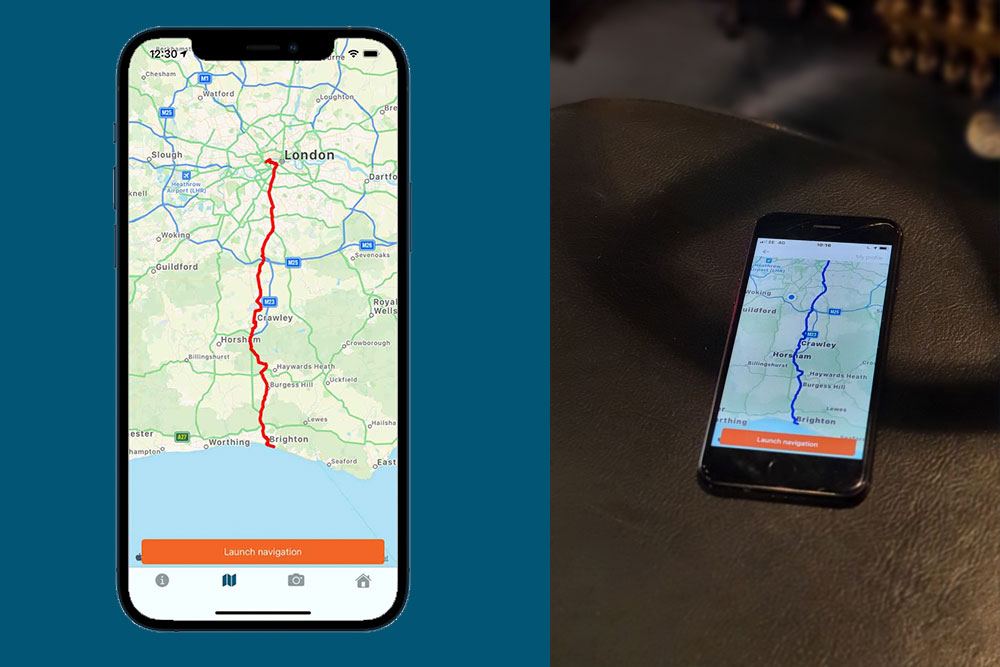
London to Brighton fixed route in the app.
In addition to the fixed route, we created a geofence that surrounded the path with a 100m radius. This allowed us to create additional triggers that would display certain IVS that I will discuss next. The aim of these warning messages was to alert drivers if they went of the designated path and instruct them to return to the correct route.
In-vehicle messages
There are currently 3 types of communication we send to users of the Eloy app:
- Turn-by-turn instructions that are aligned to the fixed route in the sat nav.
- Road guidance and safety information generated by or for the run organisers delivered as IVS. This could be things like where to stop for fuel, food, and rest, or where to get a tow – some of the veteran cars can’t make it up the steeper hills found along the London to Brighton route.
- Another set of IVS that are more danger oriented and are presented within a red box within the app, and which included warnings about going off route.
Note that all messages are also audible and delivered via text-to-speech technology.
Vehicle tracking
The final piece in our app was setting up live vehicle tracking so we could record the routes taken by participants. This allowed for some degree of live run management from a central control and more importantly the ability for a post-event review to help with future planning.
Measurement of success
A number of experiments were included in the pathfinder. For Eloy, one of the most important was testing the modified sat nav. We see many road traffic challenges which could be solved if road authorities could override sat nav systems and direct traffic to dedicated roads rather than facing overspill onto unsuitable roads.
The Veteran Car Run proved we were able to successfully override a sat nav and send the cars on a dedicated route.
For the first time we also tested Digital Diversions, where traffic control would be able to adjust a route so that different cars could take different prescribed routes. This was achieved near the start of the run where the veteran cars took two routes out of London. Following behind in a much more modern Skoda, we received a different route from the 3 cars involved in the pathfinder.
Next steps
After the success of the Veteran Car Run pathfinder, we’re now planning for further trials and events. Whilst we have shown that some of the oldest roadworthy cars can be connected, the Eloy app also works with Apple CarPlay and Android Auto. This enables the app to be viewed via car infotainment systems and integrate with the car audio system for clearer visual and audio messages.
This is particularly important for car events and everyday trips that occur across the globe in areas with poor road signage. The quality of road infrastructure and safety in countries with emerging economies tends to be lower than those in the more developed world, so connectivity, even via mobile phones, can play a big part in improving how roads are managed, and how warnings about dangers or routes can be communicated to drivers.
A video showing the value of the technology


